Get matched with top land surveyors in Lompoc, CA
Enter your zip and get matched with up to 5 pros
Need a pro for your land surveying project in Lompoc, CA?
Verified Reviews for Land Surveying pros in Lompoc, CA
*The Angi rating for Land Surveying companies in Lompoc, CA is a rating based on verified reviews from our community of homeowners who have used these pros to meet their Land Surveying needs.
*The HomeAdvisor rating for Land Surveying companies in Lompoc, CA is a rating based on verified reviews from our community of homeowners who have used these pros to meet their Land Surveying needs.
Last update on December 13, 2025
Find Land surveyors in Lompoc
California Engineering & Surveying Inc
California Engineering & Surveying Inc
Land Surveying, Land Development, ALTA Survey, ADU Survey, Civil Engineering, Tentative Maps, Parcel Maps, Tract Maps, Lot Line Adjustments, Elevation Certifications, SWPPP, Stormwater, Street Plans, Sewer Plans, Site Plans, Water Plans, Improvement Plans, Utility Plans, Grading Plans
"We had been looking for someone for weeks. Larry responded to my inquiry within 24 hours and was able to help us with the land survey in less than a week. Very pleased with his quick response. I will definitely recommend him to friends and family."
Leticia G on April 2024
Superior Surveying Services Inc
Superior Surveying Services Inc
Since 1988 Superior Surveying Services, Inc. has been professionally land surveying across the Southwest. Additional DBA - Superior Surveying SVC Inc.
Since 1988 Superior Surveying Services, Inc. has been professionally land surveying across the Southwest. Additional DBA - Superior Surveying SVC Inc.

Mashiach Exploration LLC
Mashiach Exploration LLC
Mashiach Exploration LLC is committed to our clients success. Our over 30 years of experience will lead your project needs from Permitting, Surveying, Planning, Engineering, Geological investigations, Modeling, Quality control, to Reclamation.
Mashiach Exploration LLC is committed to our clients success. Our over 30 years of experience will lead your project needs from Permitting, Surveying, Planning, Engineering, Geological investigations, Modeling, Quality control, to Reclamation.
Gallagher Company
Gallagher Company
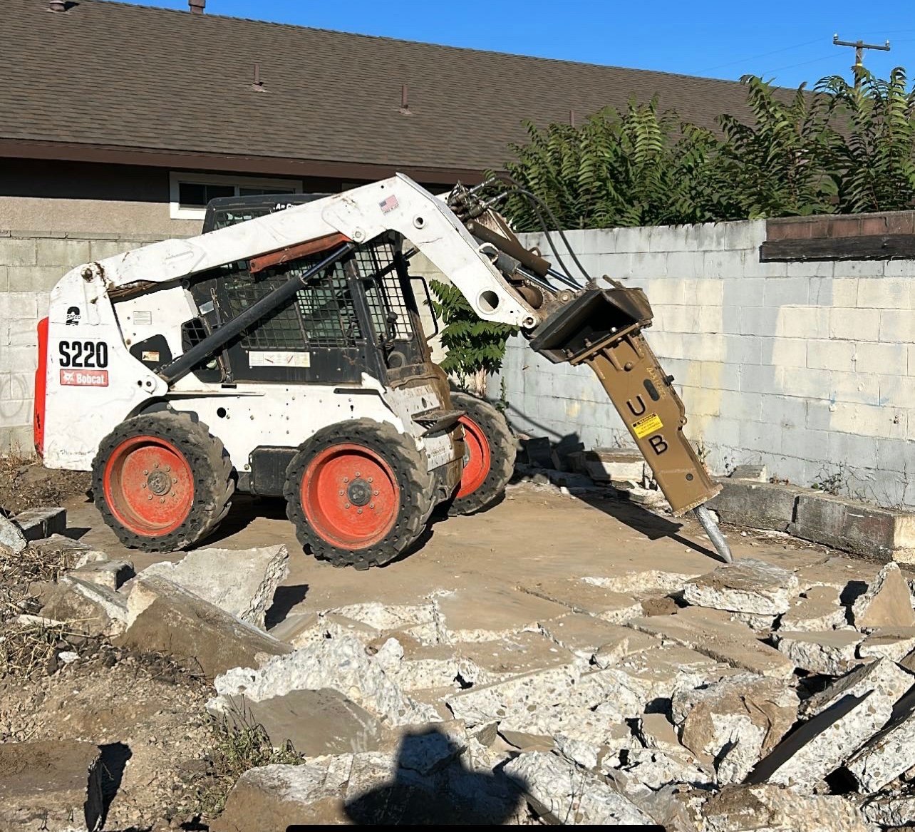
Grading, Excavation, Demolition, Septic Tanks, Underground Utilities, Building Foundations, Retaining Walls, Concrete Driveways, Drainiage Systems, Road Building, Pool Demolition and Excavation, Brush Clearance.
"Gallagher Grading did an excellent job removing 60 tons of landslide debris in two days. All excavation to dig out retaining walls, stairway, a garage and scraping and cleaning mud off my driveway was done with utmost care and no damage was incurred. Edward and his men were professional, prompt, quiet, well-mannered, and responsible. High work ethic coupled with very competitive and transparent pricing makes this company not to miss. No hidden charges, no price inflation. Job was run smoothly and efficiently and all precautions were made, taking the size of the 10 ton load trucks, not to disturb my neighbors here in Bel Air. For all excavation and grading services, I would highly recommend Gallagher Grading."
Linnell B on March 2024
LaserTech 3D Scanning
LaserTech 3D Scanning
Experience the future of surveying with LaserTech! No more waiting for weeks or months to get your survey maps. We take pride in our lightning-fast turnaround time, get your maps in just days, not weeks! Precision meets speed at LaserTech, where cutting-edge technology ensures accuracy without the long wait. Elevate your projects with the quickest and most efficient surveying services. Your timelines matter to us, and at LaserTech, we're redefining speed in the surveying industry. Contact us today for swift, accurate, and hassle-free survey maps!
Experience the future of surveying with LaserTech! No more waiting for weeks or months to get your survey maps. We take pride in our lightning-fast turnaround time, get your maps in just days, not weeks! Precision meets speed at LaserTech, where cutting-edge technology ensures accuracy without the long wait. Elevate your projects with the quickest and most efficient surveying services. Your timelines matter to us, and at LaserTech, we're redefining speed in the surveying industry. Contact us today for swift, accurate, and hassle-free survey maps!
Southwest Surveying, Inc.
Southwest Surveying, Inc.
Contact Southwest Surveying, Inc. in Joshua Tree, CA, to hire land surveying and mapping technology services.
Contact Southwest Surveying, Inc. in Joshua Tree, CA, to hire land surveying and mapping technology services.
LiDAR America inc
LiDAR America inc
Lidar America Inc, is a company specialized in Aircraft and Drone mapping, providing Lidar and photogrammetry services in aircrafts and UAS (drone). Manned (aircraft) and unmanned (Drone UAV) aerial survey with LiDAR (Light Detection and Ranging) to produce topographic Lidar products and photogrammetry images. We perform, Topographic Lidar, Lidar Aerial, Lidar Survey, Aerial Mapping, Aerial Lidar, Topographic survey, Drone Survey, UAV Survey, Drone Lidar Mapping, Aerial Drone Services, Drone Inspection and drone services in California, South Nevada and West Arizona.
Lidar America Inc, is a company specialized in Aircraft and Drone mapping, providing Lidar and photogrammetry services in aircrafts and UAS (drone). Manned (aircraft) and unmanned (Drone UAV) aerial survey with LiDAR (Light Detection and Ranging) to produce topographic Lidar products and photogrammetry images. We perform, Topographic Lidar, Lidar Aerial, Lidar Survey, Aerial Mapping, Aerial Lidar, Topographic survey, Drone Survey, UAV Survey, Drone Lidar Mapping, Aerial Drone Services, Drone Inspection and drone services in California, South Nevada and West Arizona.
The Lompoc, CA homeowners’ guide to land surveying services
From average costs to expert advice, get all the answers you need to get your job done.
 •
•Discover site preparation cost estimates, including average prices, cost factors, and tips to help homeowners budget for their next project.

A land survey can determine your property’s borders and settle property disputes. Learn how much a land survey costs and what can affect the price.
 •
•Just bought a plot of land and need to get it build-ready? Learn how much it costs to clear land to gauge your initial budget before you break ground.
 •
•Find out how much an elevation certificate costs, including average prices, cost factors, and tips to save money when hiring a surveyor for your property.

Real estate transactions often require a survey, but who pays for it? Learn who pays for a land survey in most cases and some exceptions to the norm.

Land surveys provide an accurate record of your property. Learn how long a land survey is good for and when you should have your property resurveyed.
- Vandenberg Village, CA Land surveyors
- Los Alamos, CA Land surveyors
- Buellton, CA Land surveyors
- Santa Maria, CA Land surveyors
- Solvang, CA Land surveyors
- Los Olivos, CA Land surveyors
- Santa Ynez, CA Land surveyors
- Goleta, CA Land surveyors
- Santa Barbara, CA Land surveyors
- Montecito, CA Land surveyors
- Summerland, CA Land surveyors
- Carpinteria, CA Land surveyors
- Maricopa, CA Land surveyors
- Roofing in Lompoc
- Kitchen And Bath Remodeling in Lompoc
- Plumbing in Lompoc
- Landscaping in Lompoc
- Tree Service in Lompoc
- Garage Doors in Lompoc
- Lawn And Yard Work in Lompoc
- Electrical in Lompoc
- Exterior Painting in Lompoc
- Handyman Service in Lompoc
- Pest Control in Lompoc
- Moving in Lompoc
- Carpet Cleaning in Lompoc
- Cleaning in Lompoc
- Flooring in Lompoc
- Garbage Collection in Lompoc
- Windows in Lompoc
- Siding in Lompoc
- Mailbox Repair in Lompoc
- Plaster Plaster Repair in Lompoc
- Computer Repair in Lompoc
- Epoxy Flooring in Lompoc
- Gutter Cleaning in Lompoc
- Upholstery Cleaning in Lompoc
- Drywall in Lompoc
- Leaf Removal in Lompoc
- Home Inspection in Lompoc
- Pressure Washing in Lompoc
- Swimming Pools in Lompoc
- Chimney Sweep in Lompoc
- 🌱 "Mow a small front yard"
- 🛠 "Fix a leaking pipe under the sink"
- 🏠 "Repair shingles on an asphalt roof"
