
Top-rated land surveyors.

Best land surveyors near Parrish, FL

Enter your zip and get matched with up to 5 pros

Need a pro for your land surveying project in Parrish, FL?

Select your specific project to find the pro for you.

Top-Rated Land surveyors in Parrish - Updated Nov 2026

Avatar for Terminus Surveying, LLC
Terminus Surveying, LLC
4.5(
126
)
Land Surveyor

Serving Parrish, FL and surrounding areas

Approved

In business since 2017

Free estimates

Credit card accepted

"Called multiple surveying companies with unusual project. None of the others could handle it, but Terminus never blinked. They were honest, thorough, and exceptionally easy to contact and work with. They went the extra 500 miles. I needed to contact them multiple times, and they answered immediately every time and handled every question and issue, even when it was just me being overly thorough and careful. At every stage and level, from the surveying to the legal descriptions to the deeds and processes, Terminus was always there for us. Always honest, professional and straightforward and took the time to explain everything. Great company at every stage and level. Met and/or talked to multiple members of the company from the surveyors to the office staff to the schedulers and legal describers. Great group."
Response time2 days
4 neighbors recently requested a quote
Recommended by95%of homeowners
Avatar for Aero Land Surveyors Florida Southwest, Inc.
Aero Land Surveyors Florida Southwest, Inc.
New to Angi
Land Surveyor

Serving Parrish, FL and surrounding areas

Approved

In business since 2016

Free estimates

Small jobs welcome

Aero Land Surveyors is a national land surveying firm. The company provides FEMA Elevation Flood certificates, title and mortgage surveys, residential and commercial surveying services, construction layout, property corner stakeout and ALTA surveys. The company also uses state of the art technology to create accurate surveys for existing conditions, elevations, topographic / topography, aerial, specific purpose, dock-wall re-build and other surveys.

Topo survey
Site Plan Survey
2 neighbors recently requested a quote
Avatar for Aeromatix Tech, LLC
Aeromatix Tech, LLC
3.8(
24
)
Land Surveyor

Serving Parrish, FL and surrounding areas

In business since 2020

Small jobs welcome

Credit card accepted

"First everyone else I contacted for the survey I got excuses and the price was too high and once I located this company I got the work done within a few days. He kept the price he quoted, he is very good and trustworthy."
Response time2 days
Recommended by69%of homeowners
4M Surveying & Mapping Services, Inc.
3.7(
3
)
Land Surveyor

Serving Parrish, FL and surrounding areas

In business since 2012

Free estimates

Credit card accepted

"I called the number provided by Angi for 4M Surveying and Mapping and was so pleasantly surprised when Greg answered the phone. Imagine, calling a phone number and speaking to a human! Greg provided me with a quote for my property survey within minutes and it was a great price at that. All within one phone call I received a quote and got my survey scheduled. The survey was performed quickly and the documents were mailed and sent via e-mail. It was a great experience and I know if I need another survey or anyone I know needs a survey I will recommend 4M Surveying and Mapping."
Response time40 mins
Recommended by50%of homeowners
Avatar for STRAIGHT HORIZON
STRAIGHT HORIZON
New to Angi
Land Surveyor

Serving Parrish, FL and surrounding areas

In business since 2001

Free estimates

Emergency services offered

My company provide reliable, accurate land surveying services across Central Florida, helping builders, developers, and property owners move their projects forward with confidence.\nLooking forward to the opportunity to work with you. Please feel free to contact me if you need Land Surveyor services.\n

Avatar for CDB Surveying, LLC
CDB Surveying, LLC
New to Angi
Land Surveyor

Serving Parrish, FL and surrounding areas

Free estimates

Small jobs welcome

Credit card accepted

Our Expertise Matters We are a professional land surveying company dedicated to offering high-quality boundary, topographic, and ALTA/NSPS surveys. Our services include elevation certificates and LOMA applications, ensuring accurate assessments for your real estate needs.

Avatar for West Coast Curbing LLC
West Coast Curbing LLC
5.0(
1
)
Land Surveyor

Serving Parrish, FL and surrounding areas

In business since 2023

Free estimates

Emergency services offered

"WCC did a fantastic job, from assessing our landscape curbing needs, to giving us a fair quote, they provided a flawless installation -- they were also always prompt and finished the job on time as promised! We couldn't be more happy with every part of the experience! It was truly a pleasure to have such professionalism and treatment, especially in a world that seems to lack this kind of customer-oriented care all too often. We HIGHLY recommend West Coast Curbing!!!"
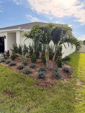
A close-up shot of the almighty Macedonian Curb, complimented by a palm tree. The Macedonian is a Rich & full, deep color layered, Natural Stone textured concrete edging design. There is nothing else in the world of landscaping that captures the raw beauty of our enhanced Macedonian Curb. Currently ranked as the #1 most favored curb design by our customers.
A front-POV shot (point of view), of the same elegant Macedonian Curb. From this angle you can experience a realistic perspective of how the Curb Edge & Border seamlessly carries the inspiringly beautiful, naturally detailed curb. Highlighting the 3-Dimensional, structural aesthetics and immaculate accuracy of the Macedonian Natural Stone Curb. Truly an architectural work of art that maximizes the appeal of any property.
https://linktr.ee/westcoastcurbing
Macedonian Concrete edge curbing border + Natural Stone + West Coast Curbing Florida + https://bit.ly/m/westcoastcurbing
Recommended by100%of homeowners
Avatar for Gear 5 Land Clearing
Gear 5 Land Clearing
New to Angi
Land Surveyor

Serving Parrish, FL and surrounding areas

Free estimates

Credit card accepted

We’re a locally owned and operated company with over 25 years of industry experience. We value honesty and integrity and treat your property as if it were our own. We offer a variety of Home Improvement services that are customizable to each individual project. We specialize in plasteringand a variety of other projects. We pride ourselves on the quality of our work as well as our commitment to outstanding results. We look forward to building lasting relationships with our clients and guarantee your satisfaction!

Additional Photos
Additional Photos
Additional Photos
Additional Photos
Additional Photos

+14

Land Surveying FAQs, answered by experts

The small lines on the tape measure either indicate inches, fractions of an inch, or centimeters and millimeters. On the imperial unit side (aka the inches side), the longest lines indicate inches, followed by the next shortest lines that indicate a half-inch, and then the quarter, eighth, and sixteenth-inch. On the metric side, the lines break down meters, centimeters, and millimeters.

Depending on the type of land survey, the report will mark the boundaries of your property, the topographical changes of the landscape, as well as major natural and added structures to the plot. A more detailed survey, like an as-built survey, will note the measurements of the structures and landscape following major construction. A topographic survey will also help your contractor determine the cost of land development projects.

You will find a collection of licensed land surveyors in your area. Your real estate agent or construction manager may also be able to recommend a trusted professional. When speaking with prospective pros in your area, ask the land surveyor if they are licensed in the state, have liability insurance, and can quote you a fee before starting.

There are a couple of ways you can determine the depth of your well. One method is to use a device called a well sounder. This tool has a long measuring tape containing a sensor to alert you once the end reaches the water. 

Or you can DIY it by using a long tape measure with a half-filled bottle of water attached to it. Lower the tape measure into your well. Once you feel tension on the tape, you’ll know the bottle has reached your static water level. This will give you an approximate idea of your well’s depth.

Depending on property size and complexity, usually 1-3 weeks.

The Parrish, FL homeowners’ guide to land surveying services

From average costs to expert advice, get all the answers you need to get your job done.