Our vision was to create a unique firm in which clients benefit from technical expertise and long-term value and business referral sources are well served through our unwavering commitment to the success of their businesses. The Partners of Riverside Land Surveying, LLC, guided by a strong work ethic, established this firm with a clear foundation: values, purpose, and competency. We strive to be a trusted advisor to our clients in a variety of practice areas that includes public infrastructure, land planning, boundary resolution, and residential and commercial development. We bring a comprehensive understanding of our client's goals to the table along.
We take great pride in our experience, expertise, quality, and customer service that we provide to meet the consumer's needs. It is our mission to provide excellent workmanship and complete customer satisfaction from start to completion of a project. In order to understand the needs and expectations of our customers, we take great care to work and communicate with every customer in a professional manner. Our reputation is based on service, safety, and quality, regardless of how large or small the job.
\n
\n
\n
Carow Land surveying is a professional Land surveying company for residential and commercial properties. We take pride in our work. Give us a call today!
TNT Professional Land Surveyors, Inc. is committed to excellence in every aspect of our business. We uphold a standard of integrity bound by fairness, honesty, and personal responsibility. Our distinction is the quality of service we bring to our customers. Accurate knowledge of our trade combined with ability is what makes us true professionals. Above all, we are watchful of our customers interests and make their concerns the basis of our business.
Welcome to Gardner Land Surveying! We are the premier professional land surveying firm offering the highest quality and most attentive care. We are known to pay exquisite attention to detail while making customer satisfaction our top priority.
\nPlease call us today to schedule your appointment.
Tri-County Land Surveying L.L.C. has been providing land surveying services throughout the State of Wisconsin since 1974. We are a complete land surveying solution, able to take care of any & all surveying needs. We deal with individuals up to large corporations & municipalities. We do it right the 1st time. & have for over 30 years. We have been registered as a land surveyor since 1969. Experience that can't be beat. We specialize in elevation certification for flood plains as well as land delineation. There is nothing our company can't do. We are statewide & our surveying crews work on a year-round basis. We're mobile so we can work virtually anywhere within the State. Call Tri County Land Surveying L.L.C. for professional experience you can trust.
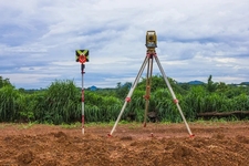
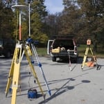
We offer a wide range of land development services for everything from lot surveys, farm acreage surveys, Certified Survey Maps, subdivision plats, commercial surveys, to construction projects and large land development projects.\n\nOur services include:\n\nLand Surveying\nFloodplain Surveying\nSite Planning\nLand Development services\nConstruction staking\n\nWe utilize the latest technologies to ensure fast and accurate results. These technologies include robotic total stations, Survey Grade GPS, electronic field data collection, and the latest software including AutoCAD for drafting which enables us to deliver our products electronically as well as on paper. These new technologies also allow us to complete projects in a much more timely manner than was previously possible.\n\nWe commonly work in Outagamie County, Winnebago County, Calumet County, Waupaca County, Shawano County, and Brown County, but we offer our services throughout the State of Wisconsin\n\n
Soil testers and licensed excavators are often the professionals you hire if you need a perc test. In some cases, structural engineers will also be able to conduct the test for you. In many municipalities, you’ll need your professional on-site to dig and fill the holes with water, as well as a representative from your local building department or health department. That representative is the individual who will determine whether your test passes or fails.
A professional land surveyor ensures accurate property boundaries and prevent legal disputes.
Detailed mapping of elevation changes and natural features on the property.
A few different types of land surveys can help determine certain features and boundaries of your property. These include:
Boundary surveys describe the actual borders of a property. These are generally required when trying to get construction permits issued.
Location surveys provide much of the same information as a boundary survey but also include in-depth information about any improvements made to your property.
Mortgage location surveys are usually required by lenders and title companies before financing or offering an insurance policy.
Site-planning surveys are done before applying for building permits and can be issued before any major home improvements.
Topographic surveys provide a formal map of land elevations. It can also describe the location and size of natural features and any land improvements.
Before property transactions or major improvements to ensure accuracy.
The Gresham, WI homeowners’ guide to land surveying services
From average costs to expert advice, get all the answers you need to get your job done.
Find out how much an elevation certificate costs, including average prices, cost factors, and tips to save money when hiring a surveyor for your property.
Planning to build a fence or home addition? Learn about land surveying costs, property boundaries, and how to hire the right local pro for your project.
If you've just been told that you need a land survey to continue your project, what time of land survey do you really need? Here are eight main options.