

Top-rated land clearing pros.

Best land clearing pros near Clay, KY

Enter your zip and get matched with up to 5 pros

Need a pro for your land clearing project in Clay, KY?

Select your specific project to find the pro for you.

Top-Rated Land clearing pros in Clay - Updated Nov 2026

Avatar for Larkins Land Worx
Larkins Land Worx
5.0(
7
)
Building Site - Preparation and Clearing

Serving Clay, KY and surrounding areas

Approved

Free estimates

Credit card accepted

Offers commercial services

"I highly recommend Larkins Land Worx! They are dependable, professional, and deliver top-notch quality work. They take pride in what they do, pay attention to detail, and make sure the job is done right and in a timely manner. It’s hard to find a company that combines reliability, professionalism, and quality workmanship, but Larkins Land Worx checks every box. You won’t be disappointed!"
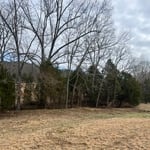
My jobs
My jobs
My jobs
My jobs
My jobs

+8

4 neighbors recently requested a quote
Avatar for The Clearing Co
The Clearing Co
5.0(
1
)
Building Site - Preparation and ClearingBuilding Site - Preparation and Clearing - For Business

Serving Clay, KY and surrounding areas

Approved

Free estimates

Credit card accepted

Offers commercial services

"Daniel at The Clearing Co did excellent work for us. He cleared new trails for ATV and tractor access that we wouldn’t have had otherwise, removed invasive plants like autumn olive and buttonbush, and cleared several massive fallen trees. Danny was respectful, communicated clearly and consistently, billed accurately, and offered competitive pricing. He followed our instructions, stayed on the property, and was flexible to our needs. The quality of his work was exactly what we needed. Thank you, Danny! I’d highly recommend The Clearing Co."
Talan and Tines Clearing
Avatar for BenchMark DirtWorx, LLC
BenchMark DirtWorx, LLC
New to Angi
Building Site - Preparation and ClearingBuilding Site - Preparation and Clearing - For Business

Serving Clay, KY and surrounding areas

Approved

In business since 2024

Free estimates

Credit card accepted

Benchmark Dirtworx is committed to excellence in every aspect of our business. We uphold a standard of integrity bound by fairness, honesty, and personal responsibility. Our distinction is the quality of service we bring to our customers. Accurate knowledge of our trade combined with ability is what makes us true professionals. Above all, we are watchful of our customers' interests and make their concerns the basis of our business.

BenchMark DirtWorx
CW Outdoor Services
New to Angi
Building Site - Preparation and Clearing

Serving Clay, KY and surrounding areas

Approved

Free estimates

Credit card accepted

Offers commercial services

We are a locally owned and operated company that values honesty and integrity and treats your home as if it were our own. We offer a variety of General Contractor services that are customizable to each individual project. You will find us to be competitively priced, paying close attention to the details of each and every project that we are involved with. We look forward to building lasting relationships and guarantee your satisfaction! \n

18 neighbors recently requested a quote
Showing 1-10 of 35
Land Clearing Services FAQs, answered by experts

A few different types of land surveys can help determine certain features and boundaries of your property. These include:

  • Boundary surveys describe the actual borders of a property. These are generally required when trying to get construction permits issued. 

  • Location surveys provide much of the same information as a boundary survey but also include in-depth information about any improvements made to your property. 

  • Mortgage location surveys are usually required by lenders and title companies before financing or offering an insurance policy. 

  • Site-planning surveys are done before applying for building permits and can be issued before any major home improvements. 

  • Topographic surveys provide a formal map of land elevations. It can also describe the location and size of natural features and any land improvements.

The small lines on the tape measure either indicate inches, fractions of an inch, or centimeters and millimeters. On the imperial unit side (aka the inches side), the longest lines indicate inches, followed by the next shortest lines that indicate a half-inch, and then the quarter, eighth, and sixteenth-inch. On the metric side, the lines break down meters, centimeters, and millimeters.

A boundary survey measures the boundary lines of the property, only the length of each property line and their locations. A land survey includes a more in-depth measurement of the property, including the heights and depths of the terrain measured by a topographic survey. A boundary survey is typically the most cost-effective method for marking and measuring property lines.

ALTA/ACSM surveys are the most comprehensive type of land survey and, as such, tend to be the most expensive. These surveys have standardized guidelines and reports and are used in many kinds of real estate transactions to ensure consistent and accurate information is available for properties.

Several government-backed lending programs can help first-time home buyers purchase a home with little money down. FHA, USDA, and VA loans are options for qualifying borrowers, though many conventional mortgage lenders will lower down payment rates to as low as 3 percent.

The Clay, KY homeowners’ guide to land clearing services

From average costs to expert advice, get all the answers you need to get your job done.