
Get matched with top land surveyors in Woodstock, AL
Enter your ZIP and get matched with up to 5 pros
Need a pro for your land surveying project in Woodstock, AL?
Select your specific project to find the pro for you.
Find Land surveyors in Woodstock
C Dubb's Land Clearing
C Dubb's Land Clearing
At C Dubb's Land Clearing, we understand the importance of transforming raw land into a canvas that suits your vision. We are thrilled to introduce our comprehensive range of services, specializing in forestry mulching, land clearing, site preparation, excavation, and dirt work. Thank you for considering C Dubb's Land Clearing for your land transformation needs. We look forward to partnering with you and bringing your customer's vision to life. Best regards, C Dubb's Land Clearing Jack Farrell
At C Dubb's Land Clearing, we understand the importance of transforming raw land into a canvas that suits your vision. We are thrilled to introduce our comprehensive range of services, specializing in forestry mulching, land clearing, site preparation, excavation, and dirt work. Thank you for considering C Dubb's Land Clearing for your land transformation needs. We look forward to partnering with you and bringing your customer's vision to life. Best regards, C Dubb's Land Clearing Jack Farrell

W&A Alabama
W&A Alabama
26 years of experience
W&A Alabama is a leading provider of LiDAR, land surveying, and land planning-related services with over 25 years of industry-related experience.
W&A Alabama is a leading provider of LiDAR, land surveying, and land planning-related services with over 25 years of industry-related experience.
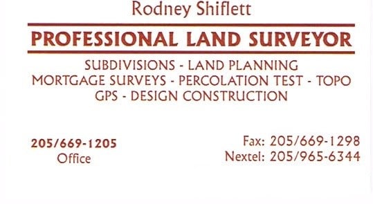
Shiflett Surveying
Shiflett Surveying
Customers say: Quick response
27 years of experience
Shiflett Surveying is a land surveying company started by Rodney Shiflett in 1998. Mr. Shiflett is involved in all aspects of every job ordered, from doing his own field work to working closely with his Autocad drafter to provide accurate and correct information.
Shiflett Surveying is a land surveying company started by Rodney Shiflett in 1998. Mr. Shiflett is involved in all aspects of every job ordered, from doing his own field work to working closely with his Autocad drafter to provide accurate and correct information.
Land Surveying questions, answered by experts
The Woodstock, AL homeowners’ guide to land surveying services
From average costs to expert advice, get all the answers you need to get your job done.
 •
•Discover site preparation cost estimates, including average prices, cost factors, and tips to help homeowners budget for their next project.

A land survey can determine your property’s borders and settle property disputes. Learn how much a land survey costs and what can affect the price.

Just bought a plot of land and need to get it build-ready? Learn how much it costs to clear land to gauge your initial budget before you break ground.

What is a property line? Find out everything you need to know about property lines, from easements to where to build a fence and how land surveys work.

If you've just been told that you need a land survey to continue your project, what time of land survey do you really need? Here are eight main options.

Land surveys provide an accurate record of your property. Learn how long a land survey is good for and when you should have your property resurveyed.
- Lake View, AL Land surveyors
- Mccalla, AL Land surveyors
- Vance, AL Land surveyors
- Coaling, AL Land surveyors
- Brookwood, AL Land surveyors
- Cottondale, AL Land surveyors
- Duncanville, AL Land surveyors
- Wilton, AL Land surveyors
- Concord, AL Land surveyors
- Hueytown, AL Land surveyors
- Maylene, AL Land surveyors
- Montevallo, AL Land surveyors
- Bessemer, AL Land surveyors
- Adger, AL Land surveyors
- Skyland, AL Land surveyors
- Alabaster, AL Land surveyors
- Lipscomb, AL Land surveyors
- Brighton, AL Land surveyors
- Saginaw, AL Land surveyors
- Tuscaloosa, AL Land surveyors
- Helena, AL Land surveyors
- Siluria, AL Land surveyors
- Pelham, AL Land surveyors
- Indian Springs, AL Land surveyors
- Plumbing in Woodstock
- Garbage Collection in Woodstock
- Cleaning in Woodstock
- Foundation Repair in Woodstock
- Roofing in Woodstock
- Tree Service in Woodstock
- Pressure Washing in Woodstock
- Gutter Cleaning in Woodstock
- Garage Doors in Woodstock
- Septic Tank in Woodstock
- Siding in Woodstock
- Kitchen And Bath Remodeling in Woodstock
- Windows in Woodstock
- Swimming Pools in Woodstock
- Electrical in Woodstock
- Dumpster Rental in Woodstock
- Lawn And Yard Work in Woodstock
- Carpet Cleaning in Woodstock
- Glass And Mirrors in Woodstock
- Floor Cleaning in Woodstock
- Garage Builders in Woodstock
- Mailbox Repair in Woodstock
- Roofing in Woodstock
- Plumbing in Woodstock
- Tree Service in Woodstock
- Electrical in Woodstock
- Kitchen And Bath Remodeling in Woodstock
- Lawn And Yard Work in Woodstock
- Foundation Repair in Woodstock
- Swimming Pools in Woodstock
What do you need done? We’ll find top pros.
- 🌱 "Mow a small front yard"
- 🛠 "Fix a leaking pipe under the sink"
- 🏠 "Repair shingles on an asphalt roof"