




Top-rated land clearing pros.

Get matched with top land clearing pros in Nancy, KY

Enter your zip and get matched with up to 5 pros

Need a pro for your land clearing project in Nancy, KY?

Select your specific project to find the pro for you.

TRUSTED BY NANCY, KY HOMEOWNERS

  • Average homeowner rating star icon4.5
    Average homeowner rating
  • Verified reviews icon89
    Verified land clearing services reviews

Find Land clearing pros in Nancy

Avatar for Thickett-B-Gone
Thickett-B-Gone
5.0(
10
)
Building Site - Preparation and Clearing

Serving Nancy, KY and surrounding areas

Approved

In business since 2023

Free estimates

Credit card accepted

"Ron and crew took down two trees, one large one very close to the house. They cleared up all debris and carted away. Ron cut the trees very low to the ground for us. Very good price, best quote we got. We would highly recommend and will use them again."
Response time4 hrs
Response rate96%
13 neighbors recently requested a quote

Logsdon’s Land Clearing & Grading
New to Angi
Building Site - Preparation and Clearing

Serving Nancy, KY and surrounding areas

Approved

In business since 2024

Free estimates

Credit card accepted

Logsdon’s Land Clearing & Grading is committed to excellence in every aspect of our business. We uphold a standard of integrity bound by fairness, honesty, and personal responsibility. Our distinction is the quality of service we bring to our customers. Accurate knowledge of our trade combined with ability is what makes us true professionals. Above all, we are watchful of our customers' interests, and make their concerns the basis of our business.\n

1 neighbors recently requested a quote
Avatar for The Excavator
The Excavator
New to Angi
Building Site - Preparation and ClearingBuilding Site - Preparation and Clearing - For Business

Serving Nancy, KY and surrounding areas

Approved

Free estimates

Emergency services offered

Small jobs welcome

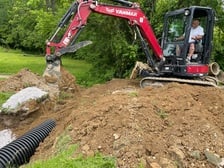
The Excavator is a family owned Excavation and concrete service located in Versailles Ky. Have been in business since 1999 and are always looking for new projects and leads. We do a lot of underground electrical work as well concrete pad and flat work. We have done many kinds of utility excavation as well general skid steer and excavations services. We offer concrete cutting and removal as well as many other services. Fast pace, reliable and quality work with everything we do. Please feel free to call Nathan at 859 227 7522 or email at [email protected]

Showing 1-10 of 34
Land Clearing Services questions, answered by experts

The small lines on the tape measure either indicate inches, fractions of an inch, or centimeters and millimeters. On the imperial unit side (aka the inches side), the longest lines indicate inches, followed by the next shortest lines that indicate a half-inch, and then the quarter, eighth, and sixteenth-inch. On the metric side, the lines break down meters, centimeters, and millimeters.

If you can’t find any records online, you’ll need to contact your county clerk’s office to do further research. They should have property records on file, or can at least point you in the right direction of who to contact. You can also speak with your neighbors about when their houses were built because they were likely built around the same time.

A boundary survey measures the boundary lines of the property, only the length of each property line and their locations. A land survey includes a more in-depth measurement of the property, including the heights and depths of the terrain measured by a topographic survey. A boundary survey is typically the most cost-effective method for marking and measuring property lines.

A land survey includes the layout of a single property, including precise measurements and to-scale drawings of boundary lines, land improvements, and sometimes other features, like topography and drainage information. A plat map includes the layouts and boundary lines of several adjacent plots and basic structure measurements. Surveys are normally more valuable for homeowners and buyers, and plat maps are for governmental use.

A land survey defines and records the physical aspects of a property, including its boundaries, dimensions, easements, features, and sometimes topographical information. In contrast, a land appraisal determines the property's monetary value. While an appraiser will often consult a land survey to understand the property's physical specifications, the survey itself does not determine the land's value.

The Nancy, KY homeowners’ guide to land clearing services

From average costs to expert advice, get all the answers you need to get your job done.